Stratigraphy
This document covers drill site stratigraphy, and lithology names that reference lithology definitions of density, surface porosity and porosity decay.
Drill site
Both backtracking and backstripping involve sediment decompaction over time. So the main input file for backtracking and backstripping is a drill site. It provides a record of the present-day litho-stratigraphy of the sediment sitting on top of the submerged oceanic or continental crust.
The difference between backtracking and backstripping is whether recorded paleo-water depths are recorded in the drill site file. When there are no recorded paleo-water depths, backtracking uses a known model of tectonic subsidence (oceanic or continental) to determine the unknown paleo-water depths. Conversely, when there is a record of paleo-water depths, backstripping uses these known paleo-water depths to determine the unknown history of tectonic subsidence.
Backtracking versus backstripping sites
ODP drill site 699 is located on deep ocean crust and has no recorded paleo-water depths:
# SiteLongitude = -30.677
# SiteLatitude = -51.542
# SurfaceAge = 0

## bottom_age bottom_depth lithology
   18.7       85.7         Diatomite 0.7 Clay 0.3
   25.0       142.0        Coccolith_ooze 0.3 Diatomite 0.5 Mud 0.2
   31.3       233.6        Coccolith_ooze 0.3 Diatomite 0.7
   31.9       243.1        Sand 1
   36.7       335.4        Coccolith_ooze 0.8 Diatomite 0.2
   40.8       382.6        Chalk 1
   54.5       496.6        Chalk 1
   55.3       516.3        Chalk 0.5 Clay 0.5
So it is suitable for backtracking, to find the unknown paleo-water depths.
In contrast, the sunrise drill site is located on shallower continental crust and has a record of paleo-water depths:
# SiteLatitude = -9.5901
# SiteLongitude = 128.1538
# SurfaceAge = 0.0000
#
## bottom_age bottom_depth min_water_depth max_water_depth lithology
   2.000      462.000      0.000           100.000         Shale           0.20       Limestone       0.75       Dolostone       0.05
   10.000     525.000      0.000           100.000         Shale           0.20       Limestone       0.75       Dolostone       0.05
   24.000     822.000      0.000           100.000         Shale           0.10       Limestone       0.80       Sand            0.10
   30.000     1062.000     0.000           100.000         Shale           0.30       Limestone       0.55       Dolostone       0.05       Sand            0.10
   34.000     1086.000     0.000           100.000         Shale           0.20       Limestone       0.10       Sand            0.70
   45.000     1366.000     0.000           100.000         Shale           0.10       Limestone       0.75       Dolostone       0.05       Sand            0.10
   58.000     1442.000     0.000           100.000         Shale           0.15       Limestone       0.15       Sand            0.70
   68.000     1494.000     50.000          200.000         Shale           0.45       Limestone       0.50       Sand            0.05
   83.000     1521.000     20.000          200.000         Shale           0.30       Limestone       0.65       Sand            0.05
   86.000     1545.000     20.000          200.000         Shale           0.55       Limestone       0.35       Sand            0.10
   88.000     1582.000     20.000          200.000         Shale           0.35       Limestone       0.65
   90.000     1620.000     20.000          200.000         Shale           0.70       Limestone       0.15       Sand            0.15
   95.000     1890.000     20.000          200.000         Shale           0.70       Limestone       0.15       Sand            0.15
   100.000    2036.000     20.000          200.000         Shale           0.70       Limestone       0.15       Sand            0.15
   107.000    2062.000     20.000          200.000         Shale           0.64       Limestone       0.18       Sand            0.18
   125.000    2066.000     0.000           100.000         Shale           0.40       Chalk           0.10       Sand            0.50
   160.000    2068.000     0.000           100.000         Shale           0.40       Limestone       0.30       Sand            0.30
   165.000    2130.000     0.000           100.000         Shale           0.40       Limestone       0.30       Sand            0.30
   170.000    2176.000     0.000           100.000         Shale           0.50       Sand            0.50
   177.000    2187.000     -10.000         25.000          Shale           0.30       Sand            0.70
   180.000    2237.000     -10.000         25.000          Shale           0.30       Sand            0.70
   190.000    2311.000     -10.000         20.000          Shale           0.30       Sand            0.70
So it is suitable for backstripping, to find the unknown history of tectonic subsidence. Note that this site records the paleo-water depths as two extra columns, for the minimum and maximum water depths. Backstripping will then use these paleo-water depths, along with sediment decompaction, to reveal the complex tectonic subsidence of rift stretching at the site location.
Note
It is possible, although perhaps not desirable, to backtrack (instead of backstrip) the sunrise drill site
to provide simulated paleo-water depths via a built-in model of continental rift stretching.
This would involve ignoring the recorded paleo-water depth columns (using the -c option of backtrack)
and supplying the start and end times of rifting (using the -rs and -re options of backtrack).
Drill site file format
As seen in the Backtracking versus backstripping sites, the file format of drill sites consist of two main sections. The top section specifies the attributes of the drill site, and the bottom section specifies the stratigraphic layers.
The attributes SiteLongitude and SiteLatitude specify the drill site location (in degrees).
Note
If SiteLongitude and SiteLatitude are not specified then they must be specified
directly in the backtrack or backstrip
module using the -w command-line option, or the well_location argument of the
pybacktrack.backtrack_and_write_well() or pybacktrack.backstrip_and_write_well() function.
For each stratigraphic layer in the drill site there is a mixture of lithologies representing the
stratigraphic composition of that layer. Each lithology (in a layer) is identified by a lithology name
and the fraction it contributes to the layer (where all the fractions must add up to 1.0).
Each lithology name is used to look up a list of lithology definitions
to obtain lithology density, surface porosity and porosity decay.
For each stratigraphic layer in the drill site there is also an age (Ma) and a depth (m) representing the bottom of that layer.
The top age and depth of each layer is the bottom age and depth of the layer above. Since the surface (top) layer
has no layer above it, the top age and depth of the surface layer are 0Ma and 0m respectively. However,
if the SurfaceAge attribute is specified then it replaces the top age of the surface layer.
A non-zero value of SurfaceAge implies that sediment deposition ended prior to present day.
In other words, it represents the age of the total sediment surface.
Note
The SurfaceAge attribute is optional, and defaults to 0Ma if not specified.
Base sediment layer
It is also possible that the sediment thickness recorded at the drill site is less than the total sediment thickness. This happens when the drill site does not penetrate all the way to the basement depth (of oceanic or continental crust). In this situation a base stratigraphic layer is automatically added during backtracking and backstripping to represent sediment from the bottom of the drill site down to the basement depth (of oceanic or continental crust).
The thickness of the base layer is the total sediment thickness minus the drill site thickness.
To determine the total sediment thickness, a grid is sampled at the drill site location. The default grid is
bundled inside pybacktrack. However, you can override this with your
own grid by using the -s command-line option in the backtrack and
backstrip modules.
The default total sediment thickness grid is:
Straume, E.O., Gaina, C., Medvedev, S., Hochmuth, K., Gohl, K., Whittaker, J. M., et al. (2019). GlobSed: Updated total sediment thickness in the world’s oceans. Geochemistry, Geophysics, Geosystems, 20. DOI: 10.1029/2018GC008115
Note
The default total sediment thickness grid was updated in pyBacktrack version 1.4.
Warning
If the drill site thickness happens to exceed the total sediment thickness then no base layer is added,
and a warning is emitted to standard error on the console.
This can happen as a result of uncertainties in the sediment thickness grid.
Note
By default, the lithology of the base layer is Shale, but can be changed using the -b command-line option in
the backtrack and backstrip modules.
You can optionally write out an amended drill site file that adds this base sediment layer. This is useful when you want to know the basement depth at the drill site location.
Note
To output an amended drill site file, specify the amended output filename using the -o command-line option
in the backtrack or backstrip module.
For example, backtracking the ODP drill site 699 (located on ocean crust):
# SiteLongitude = -30.677
# SiteLatitude = -51.542
# SurfaceAge = 0

## bottom_age bottom_depth lithology
   18.7       85.7         Diatomite 0.7 Clay 0.3
   25.0       142.0        Coccolith_ooze 0.3 Diatomite 0.5 Mud 0.2
   31.3       233.6        Coccolith_ooze 0.3 Diatomite 0.7
   31.9       243.1        Sand 1
   36.7       335.4        Coccolith_ooze 0.8 Diatomite 0.2
   40.8       382.6        Chalk 1
   54.5       496.6        Chalk 1
   55.3       516.3        Chalk 0.5 Clay 0.5
…generates the following amended drill site file:
# SiteLatitude = -51.5420
# SiteLongitude = -30.6770
# SurfaceAge = 0.0000
#
## bottom_age bottom_depth lithology
   18.700     85.700       Diatomite       0.70       Clay            0.30
   25.000     142.000      Coccolith_ooze  0.30       Diatomite       0.50       Mud             0.20
   31.300     233.600      Coccolith_ooze  0.30       Diatomite       0.70
   31.900     243.100      Sand            1.00
   36.700     335.400      Coccolith_ooze  0.80       Diatomite       0.20
   40.800     382.600      Chalk           1.00
   54.500     496.600      Chalk           1.00
   55.300     516.300      Chalk           0.50       Clay            0.50
   79.133     601.000      Shale           1.00
…containing the extra base shale layer with a bottom depth equal to the total sediment thickness and a bottom age equal to the age grid sampled at the drill site location.
For backtracking, the bottom age of this new base layer is the age of oceanic crust if the drill site is on ocean crust, or the age that rifting starts if the drill site is on continental crust (since it is assumed that deposition began when continental stretching started) - see backtrack for more details.
For backstripping, the bottom age of this new base layer is simply duplicated from the age at the bottom of the drill site (ie, bottom age of deepest stratigraphic layer). This is because, unlike backtracking, we don’t know the age of the crust. But this is fine since the decompacted output only uses the top age of each layer. And the decompacted sediment thickness/density (and hence the tectonic subsidence) still takes into account the base sediment layer and hence the total sediment thickness. Also since backstripping requires min/max recorded paleo-water depths for each layer, these are simply duplicated from the bottom layer of the drill site to the new base layer.
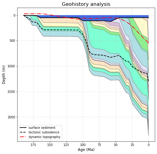
Geohistory analysis
The Geohistory Analysis notebook shows how to visualize the decompaction of stratigraphic layers of a drill site over time.
Note
The example notebooks are installed as part of the example data which can be installed by following these instructions.
That notebook decompacts drill sites in the context of backtracking and backstripping (covered in later sections), but regardless of whether we’re backstripping or backtracking we are still decompacting the sediment layers in the same way. The following image (from that notebook) shows the decompaction of a shallow continental drill site over time.
Lithology Definitions
The stratigraphy layers in a drill site contain lithology names that reference lithology definitions. Each lithology definition contains a density, a surface porosity and a porosity decay.
These definitions are stored in lithology files.
Bundled lithology definitions
There are two lithology files currently bundled
inside pybacktrack, one containing primary lithologies and the other extended lithologies.
The primary lithologies (inside pybacktrack) contains the deep-sea lithologies listed in Table 1 in the pyBacktrack paper:
Müller, R. D., Cannon, J., Williams, S. and Dutkiewicz, A., 2018, PyBacktrack 1.0: A Tool for Reconstructing Paleobathymetry on Oceanic and Continental Crust, Geochemistry, Geophysics, Geosystems, 19, 1898-1909, doi: 10.1029/2017GC007313.
# name                            density   porosity      decay
#                                   kg/m3    (%/100)          m
#
Average_ocean_floor_sediment         2647       0.66       1333    # Kominz et al. [2011]
Basalt                               2700        0.2       5000    # Turer and Maynard [2003]
Biogenic_sand                        2710       0.89       1338    # Kominz et al. [2011]
Carbonate_sand                       2710       0.48       3990    # Goldhammer [1997]
Chalk                                2710        0.7       1408    # Sclater and Christie [1980]
Clay                                 2735       0.76       1252    # Kominz et al. [2011]
Coccolith_ooze                       2710       0.59       1660    # Kominz et al. [2011]
Diatomite                            2457       0.84       436     # Kominz et al. [2011]
Dolomite                             2870       0.38       1986    # Schmoker and Halley [1982]
Limestone                            2850       0.51       4545    # Turer and Maynard [2003]
Micrite                              2710       0.69       1135    # Kominz et al. [2011]
Mud                                  2438       0.36       2015    # Van Sickel et al. [2004]
Sand                                 2650       0.49       3704    # Sclater and Christie [1980]
Shale                                2700       0.63       1960    # Sclater and Christie [1980]
Shaley_sand                          2680       0.56       2564    # Sclater and Christie [1980]
Silt                                 2661       0.76       1091    # Kominz et al. [2011]
And the extended lithologies (inside pybacktrack) mostly contain shallow-water lithologies:
Baldwin, S., 1999, Quantifying the development of a deep sedimentary basin: the Bonaparte Basin, NW Australia, PhD Thesis, Univ. of Cambridge.
# name                            density   porosity      decay
#                                   kg/m3    (%/100)          m
#
Anhydrite                            2960       0.40        500
Chert                                1929       0.65       2850
Conglomerate                         3500       0.48       2700
Dolostone                            2700       0.48       3500
Grainstone                           2700       0.48       3500
Reef                                 2700       0.10       3500
Rhyolite                             2820       0.20       2700
Salt                                 2160       0.20        750
Lithology file format
As seen in the bundled lithology definitions, the first column is the lithology name. The second column is the lithology’s sediment density (kg/m3). The third column is the surface porosity as a fraction, and fourth column is porosity decay (m).
Note
You can also use your own lithology files provided they use this format.
Porosity is the contribution of water to the sediment volume and decays exponentially with depth according to the decay constant (since sediment compaction increases with depth and squeezes out more water from between the sediment grains).
Specifying lithology definitions
Any number of lithology files can be specified. In the backtrack and
backstrip modules these are specified using the -l command-line option.
With this option you can specify one or more lithologies files including the bundled
lithologies. To specify the bundled primary and extended lithologies you specify primary and extended.
And to specify your own lithology files you provide the entire filename as usual. If you don’t specify the -l option
then it defaults to using only the primary lithologies (extended lithologies are not included by default).
Note
-l option then only the primary lithologies will be included (they are the default).-l option but do not specify primary then the primary lithologies will not be included.Conflicting lithology definitions
When specifying more than one lithology file it is possible to have conflicting definitions.
This occurs when two or more lithology files contain the same lithology name but have different values for its
density, surface porosity or porosity decay.
When there is a conflict, the lithology definition is taken from the last conflicting lithology file specified.
For example, if you specify -l primary my_conflicting_lithologies.txt then conflicting lithologies in
my_conflicting_lithologies.txt override those in primary. However, specifying the reverse order with
-l my_conflicting_lithologies.txt primary will result in primary overriding those in my_conflicting_lithologies.txt.